Solocator - GPS Field Camera
- 3.7
- Rating
- 100.00K
- Installs
- $0.99
- Price
 Analysis by App-foxy
I like photography apps that solve a practical problem instead of simply adding another filter. Solocator - GPS Field Camera takes that approach: it turns a phone photo into a visual record by placing location, compass direction, and date and time information on the image. After using it as a field documentation tool, my view is that it works best when the photograph needs to explain where and when something happened, not when the goal is artistic editing or social sharing.
That distinction matters. A normal camera gives me a clean image, while this app gives me an image with context attached to it. For checking a property, recording a site visit, documenting outdoor work, or keeping a dated visual diary, that context can be more useful than another set of filters. The trade-off is that the finished picture looks more like evidence or a work record than a polished everyday snapshot.
What makes the camera useful in the field
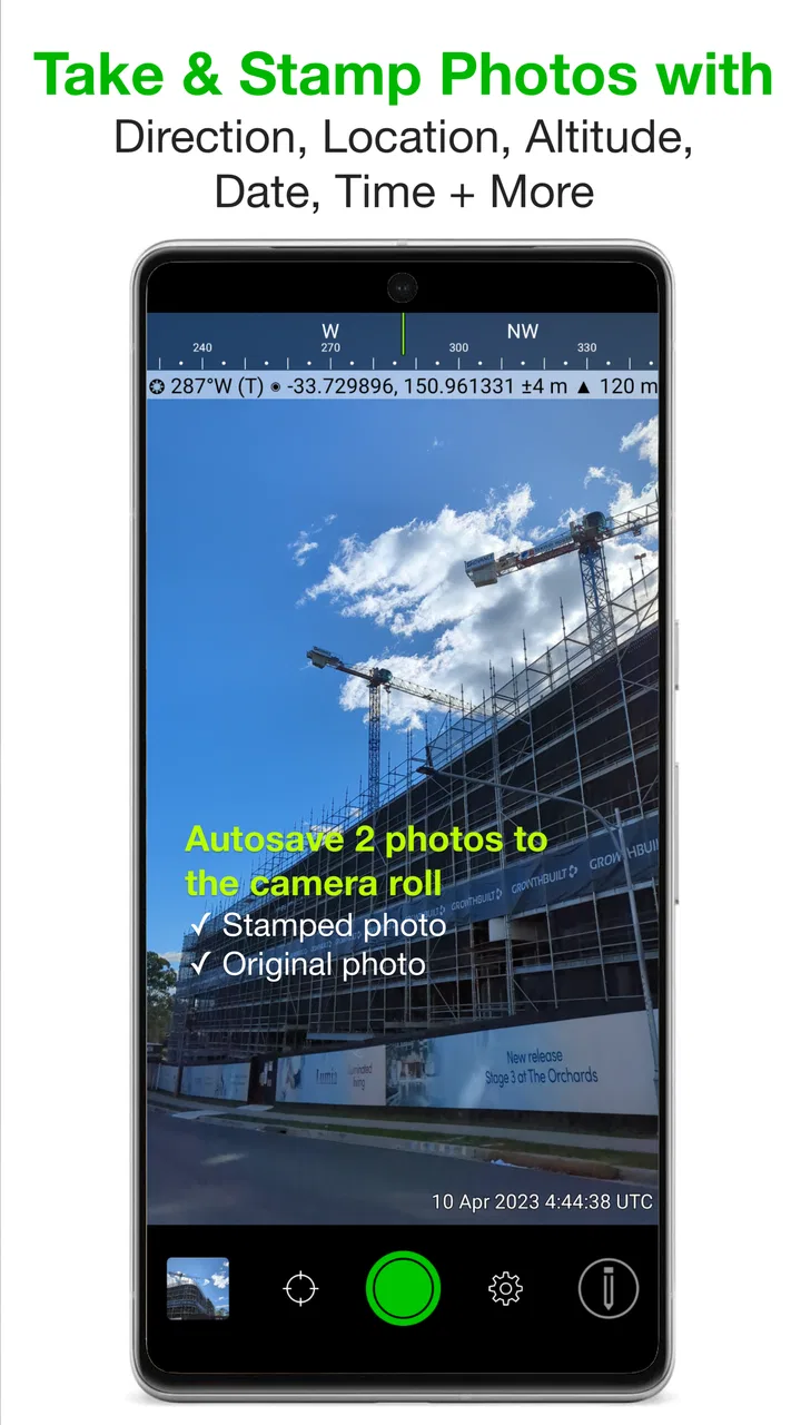
The core idea is simple, but its value becomes clearer in a real situation. Imagine walking around a building before repair work begins. Instead of taking photos and later trying to remember which wall, entrance, or damaged area each image shows, I can capture the scene with its position, direction, and timestamp visible on the photograph. When I review the images later, the markings help reconstruct the visit without relying entirely on memory.
You May Also Like

 Pandora - Music & Podcasts
Pandora’s Music Is Easy to Start, but Harder to Recover
Pandora’s strength is its low-effort path from a seed to a station. Its weak spot is how much confidence it asks you to place in connection, setup, and quiet recovery.

 8 Ball Pool
 Is Built on Rivalries, Rematches, and Routine
A close look at the rivalries, rematches, shared routines, and unanswered safety questions that turn a quick pool match into a persistent mobile community.

 Samsung Music
’s Quiet Strength Is Playing What You Already Own
Its reach comes less from spectacle than from dependable access to a personal library. That simplicity is both the app’s strongest retention engine and its ceiling.

 AccuWeather: Weather Radar
AccuWeather Review: A Quick, Clear Forecast for Everyday Decisions
For everyday plans, the best forecast is the one you can understand quickly. AccuWeather makes rain timing, radar, and local conditions easy to act on, with a few trade-offs.

 Hill Climb Racing
Why Hill Climb Racing Still Turns Crashes Into One More Run
A tiny car, a bumpy hill and one more upgrade: Hill Climb Racing keeps resurfacing because its simple chaos makes every near-miss feel personal.

 AliExpress - Shopping App
AliExpress Makes Global Shopping Feel Personal, but Shoppers Bear the Risk
AliExpress turns a global marketplace into a pocket-sized discovery engine. Its reach is useful, its shopping loop compelling, and its trade-offs easy to miss.
More From Our News Desk
View All News


The same workflow suits hikers, surveyors, inspectors, delivery teams, property owners, and anyone who needs a more accountable visual record. A photo of a trail viewpoint can carry useful orientation information. A picture of a roadside issue can be easier to discuss when its location and direction are shown directly. For personal projects, the stamps can also turn a collection of travel images into a chronological record rather than a folder of anonymous pictures.
What I appreciate is the directness. The app is not asking me to export a photo into another editor, add text manually, and then remember which details belong to which image. The information is captured as part of the camera workflow. That saves effort when I need a series of documented shots and makes the result more consistent from one image to the next.
The compass detail is especially helpful when a scene has several similar angles. A location alone may tell me where I stood, but direction gives a better clue about what I was facing. That can be useful for comparing the same area during later visits. It also reduces the need to write separate notes such as “looking toward the north side” after every photograph.
There is a subtle workflow advantage here: I can use the stamped image as the first layer of organization before adding a separate folder name, report note, or message. That does not replace proper record keeping, but it reduces the chance that a photo becomes detached from its context. For a busy day with many stops, that small improvement can save more time than a sophisticated editing feature would.
A practical way to use it for repeat visits
For recurring inspections, I would use the app consistently rather than only when something looks wrong. Photograph the same viewpoints in roughly the same order, keep the direction visible, and use the date and time to separate visits. The result is easier to compare because each image carries its own basic reference information. This is more reliable than trying to recreate a route from ordinary photos afterward.
There is also a useful distinction between documentation and proof. The stamp makes a photograph more informative, but it does not automatically turn it into a complete professional report. I would still add written notes when condition, measurements, or responsibility matter. The app is strongest as a fast visual record; it should not be treated as a replacement for a dedicated inspection system.
Another non-obvious benefit is communication. If I send a stamped image to someone who was not present, the recipient can understand the scene without asking immediately where the photo was taken or when it was captured. That is valuable in group chats and remote work, where the image may be separated from the original conversation. The stamp keeps essential orientation details attached to the picture itself.
Where it stands beside ordinary camera apps
Compared with the camera already installed on a phone, this photography app is more specialized and less flexible. The standard camera is usually better for portraits, quick family pictures, low-effort snapshots, and images that I want to edit later without visible overlays. It is also the safer choice when I want the cleanest original composition.
Compared with a notes app, the advantage is speed and consistency. A notes app can hold a photo, a description, and extra text, but it requires more deliberate organization. Here, the key visual details are placed on the image while I am taking it. That makes the process attractive for repeated field work, although a notes app remains better when the written explanation is more important than the image.
Compared with a general photo editor, the difference is even clearer. Editors are designed to improve appearance, crop, retouch, and decorate. This app is designed to preserve context. I would not choose it to make a polished travel album, but I would choose it when the direction and timing of a scene matter more than a clean frame.
It also occupies a middle ground between a regular camera and a dedicated mapping or survey tool. It is quicker and easier to carry than a specialized kit, but it does not offer the depth I would expect from software built for formal mapping, asset management, or large inspection teams. That is not a flaw in itself; it simply defines the kind of work it can handle comfortably.
Limitations that affect the decision
The most important weakness is the visible overlay. Once location, direction, and time are placed on a photo, the image can feel busy. If I am photographing a beautiful landscape or an important personal moment, the stamp may compete with the subject. I would prefer to keep a clean original for creative photography and use this app only when the contextual information is genuinely part of the purpose.
That also affects sharing. A stamped image is convenient for sending as documentation, but it may not be appropriate for every audience. The location information can reveal where a photo was taken, so I would think carefully before posting such images publicly or forwarding them outside the intended group. The feature that makes the app useful for field records can also make a picture more revealing than an ordinary snapshot.
Compass information should be treated as helpful guidance rather than unquestionable precision in every environment. Buildings, vehicles, and other surroundings can affect orientation readings, and a phone may need a moment or a suitable movement pattern to settle. For casual documentation, that is usually acceptable. For work where direction has legal, engineering, or safety consequences, I would verify the result with the appropriate equipment or procedure.
There is a similar practical caution with location. A stamped position is valuable for identifying a general place, but I would not assume that it replaces a formal survey reference or a carefully checked coordinate record. The app makes location visible and convenient; it does not remove the need for professional verification when the stakes are high.
The app is also less appealing if I already have a carefully organized workflow built around a standard camera, cloud albums, and reporting software. In that situation, adding another camera may create duplicate files or require extra sorting. Its greatest benefit comes when the stamp is needed at capture time. If I only want to add metadata later, another tool may fit better.
Cost is another part of the choice. This is a paid photography app at $0.99, and it also lists in-app purchases of $5.99 per item. I would consider that reasonable for someone who regularly needs location-marked images, but occasional users may prefer the phone camera and a manual note. The value depends less on taking pictures and more on how often the contextual stamp saves time.
The app has an Everyone content rating, which makes its intended use straightforward for a broad audience. It comes from Civi Corp and has been available since Dec 17, 2012, so it is not a new experiment built around a passing trend. Its current version is 2.8.5 and it requires iOS 8.0 or later, details worth checking before installing on an older device.
Small habits that improve the results
I would first decide whether the stamp should be prominent enough for quick reading or restrained enough to leave the subject visible. A crowded marking can hide a small detail, especially when the important part of the scene is near an edge. Taking a moment to frame the subject with the overlay in mind produces a more useful record than treating the stamp as an afterthought.
For a sequence of photos, I would keep the camera height and angle reasonably consistent. The app can preserve the contextual information, but it cannot make two viewpoints comparable if one image is taken from the ground and the next from across the street. Consistent framing turns a group of stamped photos into a much stronger before-and-after record.
I would also separate “record” shots from “presentation” shots. For example, during a property visit I might use the app for walls, entrances, fixtures, and surrounding access points, then use a regular camera for images intended for a brochure or personal album. Trying to make one image serve both purposes often produces a compromise that is neither ideal documentation nor attractive photography.
A final useful habit is to review the image immediately after capture, especially when the direction or location matters. If the phone has not settled or the composition is partly obscured, it is easier to retake the photo while still standing at the scene than to discover the problem later at a desk. This is a simple step, but it protects the main reason for using the app.
Who should install it
I would recommend it to people who repeatedly need photographs tied to place and time. Inspectors, contractors, outdoor workers, travelers keeping a route record, property managers, and homeowners documenting maintenance can all get practical value from it. It is also a good fit for someone who dislikes writing separate captions for every field image.
It may suit a casual traveler who wants a visual log of a road trip, but only if the stamped appearance is part of the appeal. If the goal is a clean album, I would use the normal camera and add a location caption later. Likewise, creative photographers, portrait photographers, and social-media users who care about an uncluttered frame should probably skip it for their main camera workflow.
Teams should think about consistency before adopting it. If several people are documenting the same project, they should agree on when to use stamped images and how to store them. The app can make each photograph self-explanatory, but it does not create a shared naming system or replace a project process. Used with a simple folder and note convention, it becomes much more effective.
Its audience is therefore narrower than the broad “camera app” label might suggest. Someone who takes photos mainly for memories may find the overlays unnecessary. Someone who takes photos to answer questions such as “where was this?” and “which direction was I facing?” is much more likely to appreciate the design.
My final assessment
After using it as a field camera rather than a creative camera, I find the concept convincing. The combination of GPS location, compass direction, and date and time addresses a real documentation need, and it does so at the moment the photo is taken. That is the app’s strongest evidence of usefulness: it reduces the gap between capturing a scene and understanding it later.
Its limitations are equally clear. The overlay can spoil an otherwise attractive image, orientation and location should not be treated as infallible professional measurements, and the paid model with additional $5.99-per-item purchases may be unnecessary for people who only take occasional pictures. The app is focused, not universal.
With an average rating of 3.7 from around 1K ratings and 228 reviews, its reception suggests a useful but specialized tool rather than an essential camera replacement. More than 100K installs show that the idea has found a real audience, especially among people who need field context attached to their images.
My recommendation is simple: choose it when a photo must carry its own location, direction, and timing, and keep a standard camera available for everything else. The best reason to use Solocator - GPS Field Camera is not better-looking photography; it is more accountable photography. For that specific job, I would recommend it to a friend. For clean creative images, I would point that friend toward the phone’s regular camera instead.
FAQs for Solocator - GPS Field Camera
01What is Solocator – GPS Field Camera used for?
Solocator is a field photography app designed to add useful location and orientation information to photos. When you take an image, it can display details such as GPS coordinates, date and time, altitude, direction, and a customizable text label directly on the picture. It is particularly useful for documenting inspections, construction progress, property visits, travel locations, outdoor activities, and other situations where visual evidence needs geographic context.
02Does Solocator work without an internet connection?
Solocator can generally capture photos with GPS and compass information when you are offline, provided your device can obtain a location signal. However, the first location fix may take longer, especially indoors or in areas with poor satellite visibility. Features that depend on online map data, address lookup, cloud services, or sharing through internet-based platforms may not work fully until a connection is restored. It is recommended to test the app before relying on it in remote areas.
03What information can be displayed on Solocator photos?
The app offers a range of overlays that can make a photo more informative, including latitude and longitude, street address, date, time, altitude, compass heading, and other project-related details. Depending on the selected layout and available device sensors, you can adjust the appearance, position, and content of the stamp. Users should review the preview carefully because GPS accuracy, address availability, and compass readings can vary depending on the environment.
04How accurate are Solocator’s GPS and compass readings?
Solocator uses your phone’s location services and sensors, so its accuracy depends on the device, weather, satellite visibility, nearby buildings, trees, and whether the compass has been calibrated. GPS readings can be less precise indoors or between tall structures, while magnetic interference may affect direction data. The app is convenient for field documentation, but photos should not automatically be treated as survey-grade evidence without independent verification or professional measuring equipment.
05Is Solocator free, and are there any limitations to consider?
Availability, pricing, and included features can depend on the operating system and the version offered in the app store. Some functions, templates, export options, or advanced customization may require an in-app purchase or paid edition. Before downloading, check the current store listing for subscription details, supported devices, privacy information, and any purchase requirements. Also remember that using GPS, the camera, and frequent location updates can increase battery consumption during extended field sessions.
Pros
- Adds GPS coordinates
- altitude
- direction
- and date directly to photos.
- Works well for documenting jobs
- properties
- travel spots
- and outdoor findings.
- Supports map views that help verify where each photo was taken.
- Customizable photo stamps let you show only the information you need.
- Useful offline when GPS is available but mobile data coverage is limited.
Cons
- Accurate location data depends on GPS signal quality and device permissions.
- Stamped photos can look cluttered when several data fields are enabled.
- Some advanced camera and export options may require an in-app purchase.
- Continuous GPS and camera use can drain the phone battery quickly.
- Privacy-conscious users may dislike embedding precise locations in shared images.

Solocator - GPS Field Camera
Gallery